Patterns.
July 3, 2012 § 1 Comment
“An appreciation of patterns in nature involves both art and science. Some of us enjoy the art and leave the science alone. And a few of us cannot take that hike into the woods or along the beach without absorbing the beauty of the moment and then searching for a new understanding about why things happen as they do.”
Patterns in Nature: An Enigmatic Inspiration:
http://richworks.in/2011/02/patterns-in-nature-an-enigmatic-inspiration/
* * *
http://www.photographersgallery.com/photo.asp?id=2423
* * *
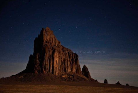
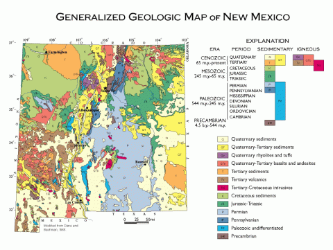
Ship Rock is a spectacular volcanic neck located within the Colorado Plateaus province in the northwestern (“Four Corners”) region of New Mexico and in the middle of Navajo country. It is part of what is known as the Chuska volcanic field, a diffuse group of small intrusions, dikes, and some extrusive rocks scattered between Gallup, New Mexico and Farmington, New Mexico.
http://vulcan.wr.usgs.gov/LivingWith/VolcanicPast/Places/volcanic_past_new_mexico.html
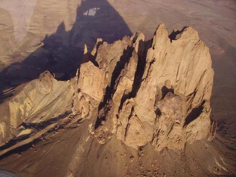
The Ship Rock landform, located in northwestern New Mexico, is the remnant of an explosive volcanic eruption that occurred around 30 million years ago. The main part of the landform is 600 meters high, and 500 meters in diameter. Ship Rock, known as Tse Bitai, or “the winged rock” in Navajo, is a volcanic neck, or the central feeder pipe of larger volcanic landform which has since eroded away. The neck is composed of fractured volcanic rock, or breccia, crosscut by many thin veins of lava. Ship Rock is composed of an unusual, highly potassic magma composition called a “minette”, thought to form by very small degrees of melting of the earth’s mantle. Ship Rock was probably 750 to 1000 meters below the land surface at the time it was formed, and has since gained its prominent form due to erosion of surrounding rocks.
* * *
http://www.geology.wisc.edu/~maher/air/air03.htm
* * *
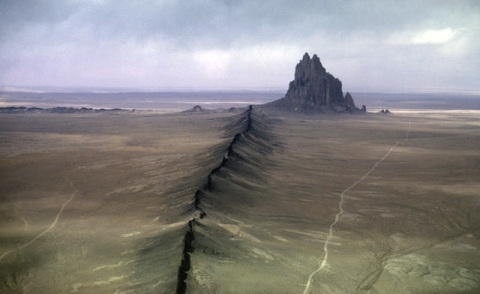
If a volcano is eroded to its roots, the cooled magma in the exposed conduit and in the feeding cracks is exposed. The eroded remnant of a steep, pipe-like conduit that feeds the central vent is called a volcanic neck. Dikes are formed by magma that has congealed in vertical cracks or tension features. They cut across the structure of adjacent rocks. Shiprock in New Mexico is a volcanic neck with radiating dikes. Erosion has stripped away the volcanic cone, leaving only the hard skeletal remains of the central vent and the vertical dikes.
http://vulcan.wr.usgs.gov/LivingWith/VolcanicPast/Places/volcanic_past_new_mexico.html
* * *
http://www.braaschphotography.com/pages/fabphotos.html
* * *
Another striking feature of Ship Rock are the dikes, or wall-like sheets of lava that radiate away from the central neck. At least two of these dikes are visible in this image. A total of six dikes have been recognized. These dikes would have been intruded at some depth below the earth’s surface at the time that the Ship Rock eruption was occurring. Like the neck, the dikes have since been exposed due to differential weathering through time of the hard lava of the dikes, and the more easily eroded sandstone and shale of the countryrocks.
http://geoinfo.nmt.edu/tour/landmarks/shiprock/home.html
* * *
Shiprock is composed of fractured volcanic breccia and black dikes of igneous rock called “minette”. It is the erosional remnant of the throat of a volcano, and the volcanic breccia formed in a diatreme. The exposed rock probably was originally formed 2,500–3000 feet below the Earth’s surface, but it was exposed after millions of years of erosion. Wall-like sheets of minette, known as dikes, radiate away from the central formation. Radiometric age determinations of the minette establish that these volcanic rocks solidified about 27 million years ago. Shiprock is in the northeastern part of the Navajo Volcanic Field; the field includes intrusions and flows of minette and other unusual igneous rocks that formed about 25 million years ago. Agathla, also called El Capitan, is another prominent volcanic neck of this field.
http://www.discovernewmexico.com/parks_and_monuments/shiprock.htm
* * *
http://geologycafe.com/class/week4.html
* * *
Chuska-Ship Rock (Navajo) field:
http://www.nmnaturalhistory.org/chuska-ship-rock-navajo-field.html
* * *
http://alantowerphoto.com/fine-art-photo-gallery-1/
* * *
“Our earth is very old, an old warrior that has lived through many battles. Nevertheless, the face of it is still changing, and science sees no certain limit of time for its stately evolution. Our solid earth, apparently so stable, inert, and finished, is changing, mobile, and still evolving. Its major quakings are largely the echoes of that divine far-off event, the building of our noble mountains. The lava floods and intriguing volcanoes tell us of the plasticity, mobility, of the deep interior of the globe. The slow coming and going of ancient shallow seas on the continental plateaus tell us of the rhythmic distortion of the deep interior-deep-seated flow and changes of volume. Mountain chains prove the earth’s solid crust itself to be mobile in high degree. And the secret of it all—the secret of the earthquake, the secret of the ‘temple of fire,’ the secret of the ocean basin, the secret of the highland—is in the heart of the earth, forever invisible to human eyes.” – Reginald Aldworth Daly, Our Mobile Earth (1926), 320.
* * *
Sunday January 8, 2012 Quote du jour
January 8, 2012 § Leave a comment
http://kenhurstphotography.photoshelter.com/image/I0000RYjYajKvq6c
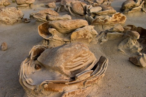
“There are plenty of ruined buildings in the world, but no ruined stones.” – Hugh Macdiarmid
http://richardbarron.net/traveller/2003/11/30/desert-cold-november-2003/
http://geology.about.com/library/bl/maps/n_statemap_NM.htm


